 Pendleton County was formed in 1798
, and named for the
Honorable Edmund Pendleton, of Virginia. It is situated in the northern section of the state, nearly square in shape, and embraces about 300 square miles.
Pendleton County was formed by taking portions from Bracken and Campbell counties, and thus it became the 28th county in the state.
On December 13, 1796, the General Assembly approved an act "for erecting a new county out of the Counties of Campbell and Bracken." After May 10, 1799, "all that part of the county of Bracken and Campbell, within the following bounds, viz. Beginning on the Ohio river two miles below the mouth of Big Stepstone creek; thence a direct line across Main Licking, as far below the main forks of Licking, as it is from that place to the mouth of the north fork of Licking, above the said forks, to continue said line south seventy-six degrees west, until it shall strike the Scott and Franklin lines; thence with the same to the Harrison county line; thence with the same to Main Licking, to the mouth of the north fork; thence a direct line to the mouth of Big Stepstone, and down the Ohio to the beginning, shall be a distinct county, and called and known by the name Pendleton..."
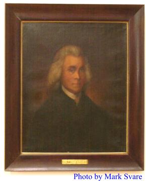
The name was chosen by Virginians who settled in Falmouth, in honor and recognition of the wonderful service Edmond Pendleton rendered to his people in Virginia. Edmond Pendleton, plus being a get statesman, was one of the surveyors of his part of the state. He was born in Caroline County, Virginia in 1721, and died in Richmond, Virginia in 1803, five years after Pendleton County was named for him.
Pendleton County has two rivers, Main Licking and South Licking, with many tributaries supplying their water. Among these rivers and streams are rich bottoms of land, Hayes Station Bottoms, Menzie Bottoms, South Licking River Bottoms at Morgan and the Main Licking River Bottoms above Falmouth, the rest of the land being rolling and hilly and based on limestone.
Falmouth, its largest town and county seat, is located at the confluence of the Main and South branches at the Licking River, is 39 miles south of Cincinnati. It was established in 1793. The name Falmouth was chosen by Virginians who came from
Falmouth, Stafford County, Virginia.
Some of the smaller communities established in the county over the years were: Morgan, Callensville, Goforth, DeMossville, Grassy Creek, Boston Station, Peach Grove, Bachelor's Rest, McKenneysburg, Mt. Auburn, Portland, Knoxville, Gardnersville, Short Creek, Concord, Flour Creek, Blanket Creek, Roanoke, Oakland, Turner Ridge, Richland and several others that we may not have listed. Many of the communities at one time had schools, general stores, and were very busy little communities.
In March 1860, Catawba and DeMossville were incorporated, Boston Station and Butler were incorporated in February 1868.
Historically, Falmouth is known as the landing place for Colonel Henry Byrd, British Commander, of British, French and Indian forces numbering 600 men, who marched on Ruddle's Station in Harrison and Bourbon counties.
There was never a great Indian battle at or near Falmouth, but within a few hundred yards of the boundaries of Falmouth, remains of an ancient fortification were visible until about 1850. It was situated upon elevated and commanding ground, midway between the two rivers. In form, it was a regular circle with four apertures or openings, opposite each other, and corresponding very nearly to the four points of the compass.
Pendleton County was a beehive of activity during the Civil War or War Between the States, and while no battles were fought here, both Northern and Southern troops passed through here en route to battle in central Kentucky or into Tennessee and Georgia.
Pendleton County was one of the first counties in Kentucky to produce tobacco. The first tobacco grown in the county was called twist-bud, a heavy type of burley used principally for chewing tobacco and snuff. Later the white burley type became prominently grown in the county. Tradition has it that the first tobacco raised in Pendleton County was produced in the McKenneysburg area. The price paid in the 1830s was one to four cents per pound.
On April 1964, a flood hit the cities of Falmouth and Butler and caused extensive damage up in the millions of dollars.
A tornado struck Pendleton County in March of 1968 and did quite a lot of damage in the county. The city of Falmouth was hit the hardest with an estimated damage loss of around $7 million dollars. There were three people killed during the tornado.
Pendleton County also suffered the worst flooding in history on March 1, 1997, which cost the county severely in dollars and took a toll of five lives. With the Licking Rivers cresting at 52 feet on March 2, both cities of Falmouth and Butler and outlying areas were under water for several days. Over 600 homes in the flooded terrain were affected.
The county also has an airport,
Gene Snyder Airport, located on Highway #22, west of Falmouth.
Education is supplied by Pendleton County Memorial High School, Phillip A. Sharp Middle School and Northern and Southern Elementary Schools.
The county also has
Kincaid Lake State Park, from which all land was donated to the Commonwealth of Kentucky by local citizens. The beautiful park consists of 800 acres. The park was opened in 1963.